At the last minute, we decided to take a drive to the town of Creede, about an hour drive northeast from Pagosa Springs. I had read that the town was an interesting place and with a "rich" mining history too. Of course, that means a trip over scenic Wolf Creek Pass. Let's go!
 |
| Another view from Lobo Lookout, the summit of Wolf Creek Pass. |
 |
| A view of the Wolf Creek Ski Area and Hwy 160 as it travels over Wolf Creek Pass. |
The town of Creede has a colorful history of 1890's boom-town mining and gambling. Highway 149, also known as The Silver Thread Scenic Byway, runs through Creede as well as other small historic mining towns. We didn't make any special plans or research anything other than "let's get in the Jeep and go" so we didn't have but an afternoon to explore the town and the surrounding area.
 |
| Driving into town, we could see that it was a place we would love to explore. Small shops with old store fronts, restaurants, art galleries, ice cream.... |
We continued to the end of town, where we could see that the road seemed to go up into a canyon. Ronnie just kept driving to see where it would lead.
 |
| We were intrigued by the creek that was channeled into a man-made ditch. (Willow Creek) |
As we rounded the curve, we traveled between the canyon walls to find an abandoned, yet very unique mining landscape. We could see towering cliffs, interpretive signs and a gravel road seemingly, tempting us to go up further into the deep canyon.
 |
| You can see the switchbacks from the old mining days here. Horse drawn wagons were used to transport the silver and lead rock ore down that path. |
The interpretive signs informed us that this was called the Bachelor Loop. We were excited now..another scenic "Jeeping" road to explore with not just gorgeous scenery but some interesting history too!

Traveling up this gravel road, we suspect we are in for a real treat.

As we ride up the steep hill, we come upon an awesome sight of old, abandoned mines from the 1890's! Wow, what history!

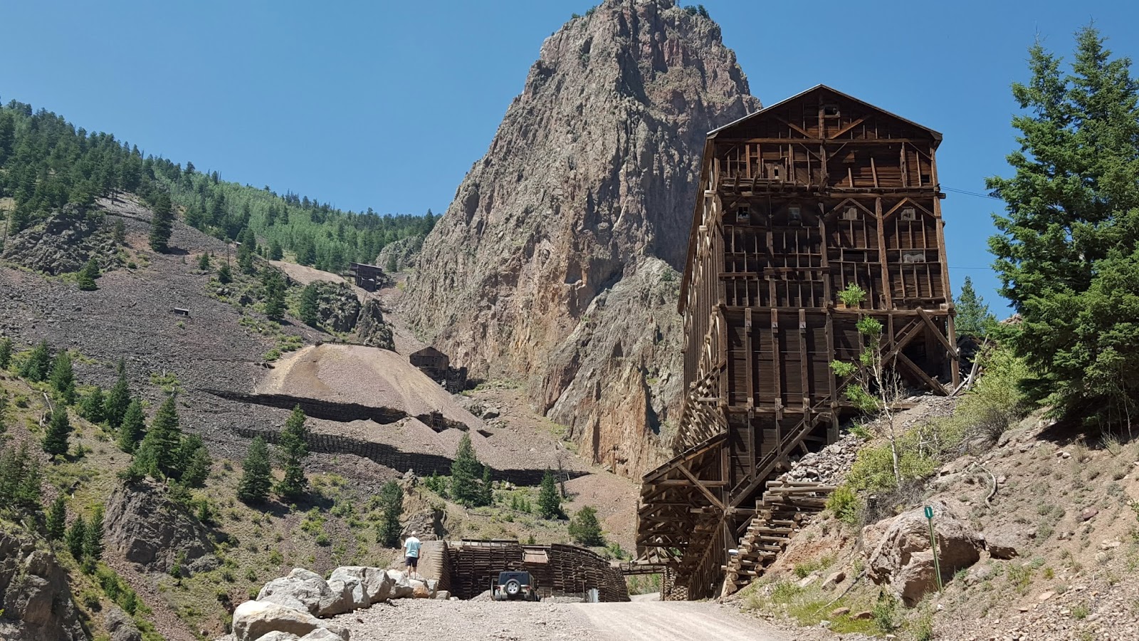 |
| We learn that this is the Commodore Mine, last used in 1976. |
 |
| Zoomed in view of the mines further up on the cliff. |

Ronnie and I find it interesting to see old mining equipment just lying around. The interpretive signs remind people to leave the historical evidence and abandoned mines alone as it is all on private property and many are unsafe. Ron notes that this sheet metal is riveted together, not welded, possibly a clue to the age of all this mining equipment.

 |
| There is evidence of smaller mines along the roadsides and up on the cliffs. |
We continue straight up this 17 mile gravel road..

...stopping to take photographs and marvel at the enormous cliffs surrounding us.

We turn around to see where we have come. Again, another "Wow, look at that!" moment.

The next sites we arrive at are the Amethyst and Last Chance Mines.

Across the road we notice another possible mine entrance. I'm not going in there.

The Bachelor Loop twists and turns upwards and gradually levels out at around 10,000 feet. We pass by a few other abandoned mines and a couple of mines that have appear to have been sealed.

While we were traveling the loop, the discussion came up between us about the mining waste water spill on the Animas River. We soon came upon the Park Regent Mine Site. It was sealed in 2003 using cement and kiln dust.
 |
| Nelson Mountain (12,099ft) is in the background. |
Here is the interpretive sign describing the reclamation process used to seal this particular mine. Note the "After" paragraph. Various Mining Reclamation Committees were involved in this process.

We came to a fork in the road that lead to The Last Chance Mine. We started down the path to visit the mine but gave up and turned around after we realized our afternoon time was running out. We continued on the rest of the 17 mile loop where it soon passed an impressive lookout over the valley. This area is where the old mining town of Bachelor City was once located. Only sparse remnants of the once bustling town remain in the aspen groves.
Oh..but the view!
Oh..but the view!

We found end of the Bachelor Loop as beautiful and stunning as the beginning.


We had just enough time left to stroll along Creede's main street and into a couple of shops. We did get a bite to eat at Kip's Grill and it was very tasty. Unfortunately for us though, we missed visiting the Underground Mining Museum and the Historical Society's Museum, as they had closed for the day. It would have been interesting to compare the western, historical mining artifacts/history to the modern ones we found in Lynch, Kentucky(from our blog post in September 2014).

I did catch a glimpse of this wonderful mural in Creede.

More later.
Well, you finally got to Creed. We spent nine days there. Wasn't the bachelor loop amazing. Joel and I were in the vette there, didn't know the road was so dicey. But it was worth it. We enjoyed that town but had no cell phone or internet there. Glad to see you are enjoying the trip. We looked at new modular homes today in a nice community with loads of activities and such. Looks like we will buy it. It isn't cheap but our motorhome cost more. They have a gorgeous waterfront lot to put it on and we will get a pontoon boat, it is on the chain of lakes. Looking forward to hearing from you soon. Sincerely, esta and joel and peanut and birds.
ReplyDelete