Monday, July 26, 2021

Summertime in Anacortes, Washington

Seeking cool temperatures, lower humidity, locally grown fresh fruits and vegetables, great seafood and landscape/seascape scenery at its best, we finally reach our summer destination: Washington's northwest coast.  Ronnie and I first visited this area in July 2016, to look back on that time click Anacortes: 2016.  We have found this part of the USA to be very inviting climate wise and with so many other activities to explore here, we told ourselves we would love to come back one day.  Making our way from Coburg, Oregon, our 2 day trip on Interstate 5 took us through Seattle and on northward to the Skagit River Valley in Washington.

 The clear view of downtown Seattle, from the new motorhome windshield.


Returning back to Anacortes has been a lot of fun, especially rediscovering some of those memorable places we experienced in 2016.  Sunset Beach, located in Washington Park, was as cool and serene as we remembered.


 Wow, the blueberries are in season and are they huge!  We loaded up with ten pounds of those plump, sweet berries.  We didn't take the time to enjoy this treat 5 years ago.


 The Anacortes Saturday Farmers Market was a favorite memory.  On our first visit back this trip, we rediscovered many of our favorite goodies.  We plan to revisit the Farmers Market often.


 Our lazy picnic lunch this day on Washington Park's Sunset Beach and a drive through the Park's old growth forest was as cool as we remembered too.


 Reaching the high point of Washington Park's look out point, we get a southern view of Fidalgo Island and Anacortes' south-facing Flounder Bay.


 A view of Borrows Pass, as the tide pours back to the Pacific Ocean.


 I've taken these photographs before but it's still fun to make those pictures again and revisit places that made a special, happy impression in your memory.


This northern view from Fidalgo Island, across from a residential section of Anacortes, is Padilla Bay.  The tall mountain way off into the background is Mt. Baker. 


 We never did make it to Mt. Vernon's Farmers Market back in 2016.  Today's visit does not disappoint, we found many of the same farm vendors from Anacortes selling fresh picked goodies and tasty baked treats.


 And just like 2016, our dear friends John and Suzanne are here too.  We are looking forward to making more special, new memories.


More later from
Anacortes, Washington.

Monday, July 19, 2021

Sheridan, Wyoming to Coburg, Oregon

Ronnie and I were all excited that the windshield had been repaired, but unfortunately when we pulled out we discovered that the windshield installer had made some mistakes in the installation.  We made the decision to travel on to Sheridan, Wyoming where once there, Ronnie immediately contacted RV Glass Solutions/Coach Glass.  Working with their experts, Ronnie and I agreed the best option for a correct re installation would be to travel to their facility in Coburg, Oregon.  They will personally handle the re-installation and add a new windshield gasket too.  We were traveling towards that westward destination anyway so it made sense.  But before we leave, we do make a couple of interesting side trips while in Sheridan.

We enjoyed a day trip on Highway 14 South through the Big Horn Mountains.

Here the road climbs up into the mountains with spectacular valley views below.

 Reaching Highway 14 South's highest point at 9430 feet.


 We take a forest service road off the main highway to enjoy a quiet lunch in the thick evergreen woods.


 A variety of blue lupine wildflowers, I think?


 I found this one little patch of wildflower iris.


 We spotted a moose across the highway.  When we stopped to make a photograph, it quickly gave us a show of its leaping skills.


 Continuing westward now on Highway 14, the road drops in altitude and the land changes dramatically.


Now we're back into a dry, arid Wyoming landscape.


 We made a day trip to the Brinton Museum.  To learn more about this amazing museum of Native American Art and the Brinton Family, click HERE.


 The Brinton Family collected several important pieces of Native American art, all displayed here in a beautiful, natural setting.  The unique museum building, seemingly immersed into the landscape, gave it an appeal of being one with nature.  Our lunch in their Bistro was delicious while we looked out over the mountains on this cool, rainy day.  We missed strolling the gardens, the ranch home and the leather craft shop.  We'll catch those experiences another day.


 We also had the opportunity to visit the weekly Sheridan's Farmers Market.  Before the market began, we made a quick stop in the King's Saddlery Shop.  This quick stop turned into 2 hours!  We were bowled over with the museum in the back of the store.  Don King was a widely known saddle-maker and leather artist.  He also had an amazing collection of Native American Art, his own saddle collection (over 600 saddles!) and who knows how many antique guns, historic photographs, animal mounts, western ranch tools of trade and so many unique items of the west.  We found so many things to look at and learn about that it became hard to realize it all, we were overwhelmed.  To learn more about this MUST STOP while in Sheridan, Wyoming, click HERE.

 
Ronnie standing among some of the many saddles and artifacts of American western culture.  This is just one room of four that are stuffed full of artifacts, antiques and cowboy memorabilia.
 
 
 King's Saddlery ropes are known and sold world wide.

 
These photos are just a small hint of all the many unusual and unique western items we observed. 
 

Ronnie drove from Sheridan, Wyoming to Coburg, Oregon (approximately 1200 miles) in 4 days.  It was quick and mostly Interstate highway travel.  Some of the remarkable sights we saw were the wheat fields of western Washington and western Oregon.


 Wheat fields and brown, dry hills along the Columbia River.


 A contrasting green vineyard on the Washington side across the Columbia River.


 A view of the Columbia River through a buggy windshield.  The further west we traveled along Interstate 84 (the Oregon side), the more the vegetation changed from dry, brown hay to lush evergreen forests.


 Once we arrived to Coburg, Oregon, RV Glass Solutions got to work and they made the job right.  We made good use of our time that day away from the motorhome visiting Thistledown Farms.  We purchased fresh fruit and vegetables grown in Oregon's Willamette Valley.


The peaches were divine, wish we had purchased more.  Those giant blackberries were the largest we had ever seen!


RV Glass Solutions / Coach Glass of Coburg, Oregon

If the new windshield breaks, they have another!

 All done, what a relief.
 

 The new windshield, correctly in its place.
 
More later from Anacortes, Washington.


Wednesday, July 7, 2021

Independence Rock

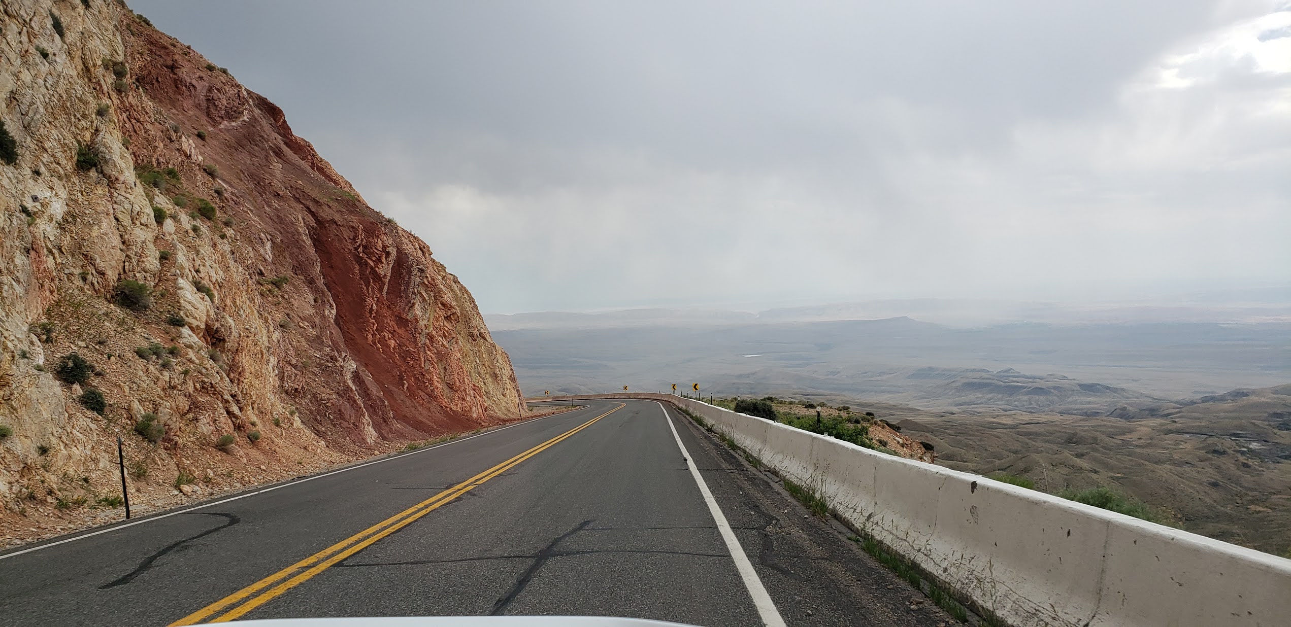
Because shipping seems to be a little slower now due to the recovering economy, tracking info showed the windshield stalled in Denver for an extra day.  That gave us time while in Rawlins to make a day trip out to Independence Rock.  Located on Wyoming Highway 220, this landmark was the midway point on the Oregon Trail, the Mormon Trail, The Overland Express Trail and the California Trail.  We enjoyed a half day here exploring Martin's Cove, the Devil's Gate and Independence Rock all located within about 3 miles.

 The first stop on Wyoming Highway 220 about 2 miles south of  Independence Rock is Martin's Cove.  To learn more about Martin's Cove and its history, click HERE.  This area was the campsite location used by the Martin Handcart Company after the rescue of 2 of their companies in 1856.  Unfortunately because of several factors: bad weather, lack of food, illness, exhaustion and the decision to leave too late in the year, it all lead to the loss of between 135 and 150 emigrant lives here.  This was the greatest loss of life from any single event during the entire Westward migration period.

Entrance way to Martin's Cove

That crack in the rock is called the Devil's Gate.  Eroded by the waters of the Sweetwater River, this crack was a notable landmark used by all travelers on the Trails.  The Devil's Gate and Martin's Cove are all in one area.


Now a working ranch owned the Church of Latter Day Saints, Martin's Cove is also a museum and Interpretive Center.  The first homesteaders were the Sun Family.  Settling here in 1872, Tom Sun Sr. built his cabin near the Devil's Gate and the Sweetwater River Valley.  A small section of the building shown below is part of his original cabin.  It has been restored and now houses a museum of their family artifacts, info about the Martin Handcart Company and the sad fate of the two companies of emigrants that camped here.


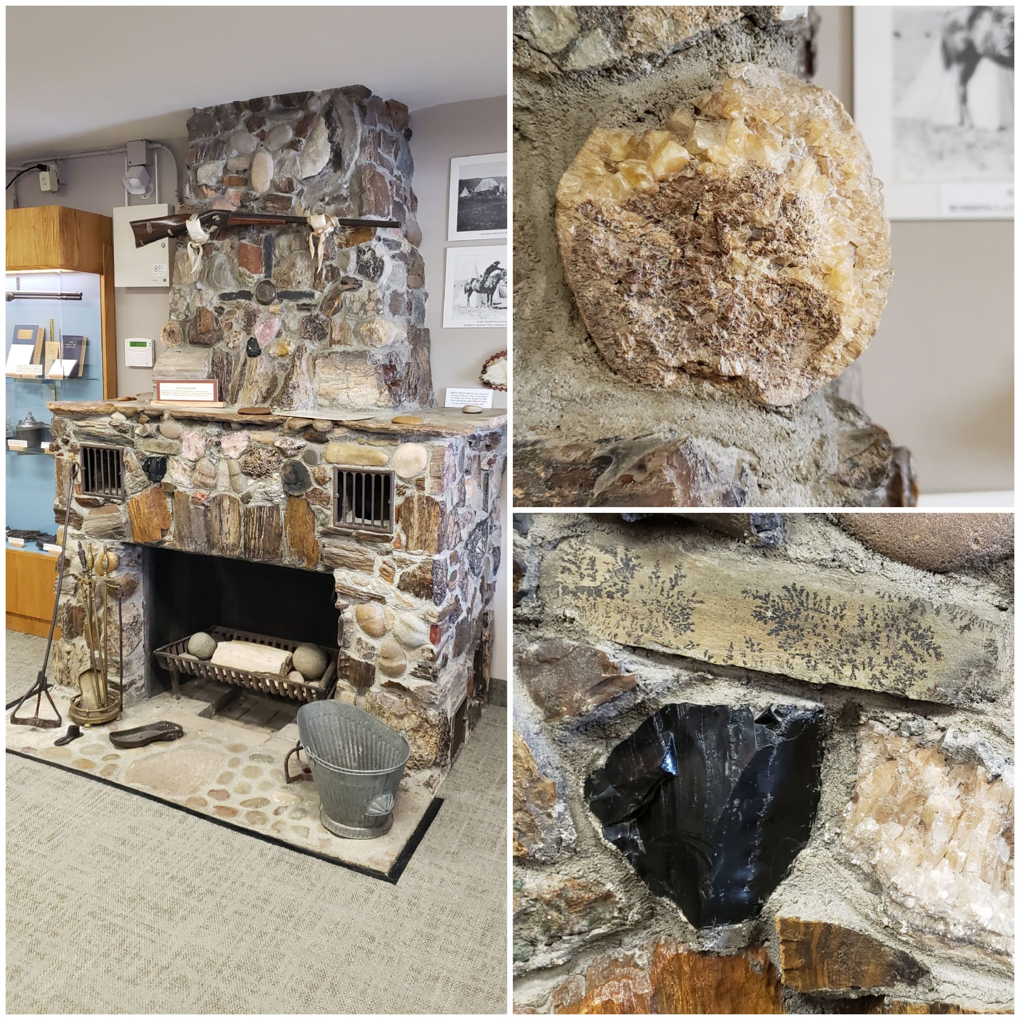
Inside the museum was this beautiful stone fireplace consisting of different types of rock.  Tom Sun's wife loved to collect rocks, even receiving some as gifts from travelers as they passed by their homestead.  She used her rock collection to create this unusual fireplace.

Top right, that's a petrified Wooly Mammoth tusk, Lower right, obsidian rock.

This Evans Lever Action Rifle, made in 1873, was a gift to Tom Sun Sr. from Buffalo Bill.  Their early friendship was instrumental in developing Buffalo Bill's sharp shooting skills.

 
Here is a wider view of this national historic landmark ranch.  Note the large crack in the mountain side, that is the Devil's Gate landmark.

These small granite monuments mark the Oregon Trail Crossing and the unfortunate loss of life of the pioneers.  These were in the parking lot at Martin's Cove.

The Devil's Gate landmark can be seen on the left below and the road path is the actual Trail that travels through Rattlesnake Pass.  All travelers on their way West passed by here.


A second overlook on Hwy 220 offers another view of the westward travelers' Trails.  Imagine wagon trains of emigrants, fur trappers on horses, people pulling and pushing handcarts and the Overland Stage heading west in search of a better, more productive life.

A view of Rattlesnake Pass.

Landmarks: the Devil's Gate and Rattlesnake Pass.  Travelers knew they were on the right trail when they saw that crack in the rock.


Walking along the paved walkway at the Devil's Gate Overlook I spotted a snake skin in the grass. We moved right along!


Continuing north on Hwy 220, we spot the Independence Rock.


The historic landmark now hosts a modern rest area with facilities for travelers.


White stick markers denote the 4 different Trail pathways.  If you look closely you can still see evidence (depressed earth) where the Trail goes to the right.


The state of Wyoming provides a paved walking path to Independence Rock and the scratched inscriptions made by emigrants.


Ronnie was tempted to climb the rock to see the more preserved inscriptions on top but it's the middle of the day when we're here and the temperature is too warm.  We did see several young families climb it however.


In order to protect what is left of the emigrants' carvings, this metal fence keeps people away from the rock face.  Due to natural weathering, these inscriptions are difficult to see now.  Unfortunately they will not be here many more years.


We did see plaques added to the rock denoting significant inscriptions.  Carving names and dates was a way the emigrants communicated to other passing travelers and family that they had made it this far.

All of these markers and the carved inscriptions are protected by a high fence and barbed wire.  There are more carved inscriptions on the top of Independence Rock, they can be found under rock outcroppings and better weather protected areas of the rock.  Unfortunately you've got to climb to the top of the rock to see them.

This plaque honors Oregon Trail blazer Ezra Meeker.  To learn more about him and his importance to the preservation of the Oregon Trail landmarks, click HERE,


Granite marker installed by the state of Wyoming in 1914.


Emigrant inscriptions are still visible today but barely.  We could only make out a letter here and there.


Remnants of an old highway pass by Independence Rock, it goes off into the distance.


One more view of what the travelers on the Oregon Trail saw as they left Independence Rock headed towards Rattlesnake Pass.


This rancher's road seems to follow the Trail once it crosses Hwy 220.


More later from

Sheridan, Wyoming.