Monday, August 31, 2015

What A Pleasant Rocky Mountain High

We leave the charming, mountainous area of Pagosa Springs tomorrow.  Our month at The Last Resort Campground has been comfortable, very quiet and relaxing.  Fortunately we were assigned one of their best campsites which made our stay even better. Ron and I are glad we chose this area of Colorado to explore and this campground for our home-base.  We've enjoyed fantastic mountain scenery, some exciting Jeep trails, great campground hosts, cool weather and the soothing effects of the hot springs.

We spent our last Saturday morning wondering around the Pagosa Springs Farmer's Market.  We bought a variety of items this day: fresh Colorado peaches, tomatoes and spices.  Other visits to this market have found us leaving with homemade berry pies, strawberry-rhubarb jam, lemon cucumbers? a piece of crafted jewelry and peppermint hand lotion.

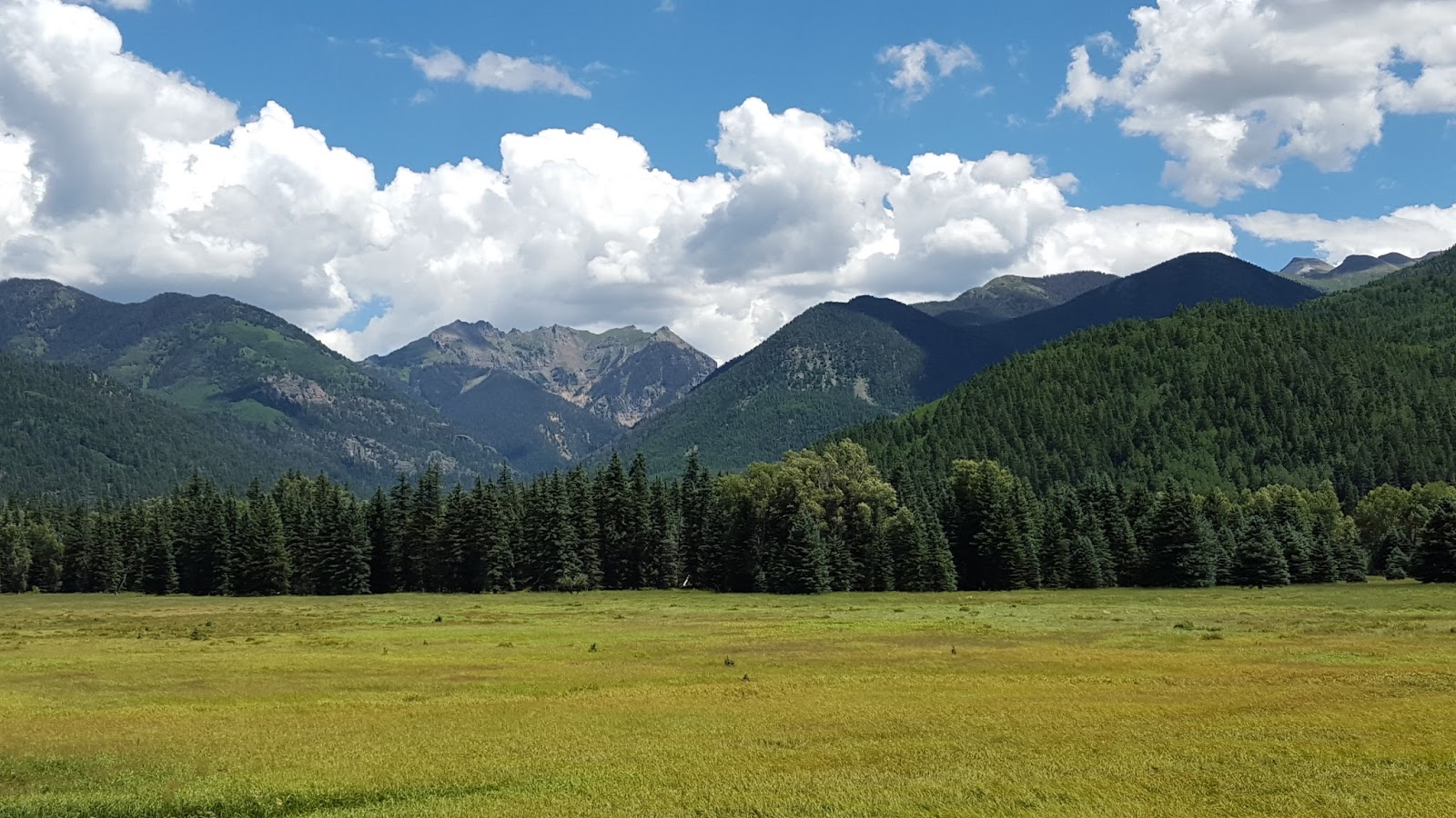
We feel like we have been on about every dirt road here!  We have had a ball and have seen some of the most wonderful Rocky Mountain scenery.
Our Jeep trail ride to Williams Creek Reservoir provided us with more of that awesome Colorado scenery.  This trail is part of the Piedra Area/Weminuche Wilderness.
We always take lunch with us when we go out exploring in the Jeep.  What a great choice for our picnic this day!
Williams Creek Reservoir has been my favorite place so far.

Another trail we enjoyed was the Mill Creek-Nipple Mountain Road.

This day, the white daisies were in full bloom.
The road ended at this spectacular lookout point.
Behind us..

This westward direction in front of us looked out over Echo Lake and the San Juan River area.

Of course we wanted to travel back over Wolf Creek Pass again.  Our excuse this time was to explore the Big Meadows Reservoir. We were stunned to see this recently burned area northwest of the Reservoir. The West Fork/Big Meadows Forest Fire burned over 80,000 acres in 2013.  The fire was made worse by the hundreds of dead trees killed by the spruce beetles.

However, Big Meadows Reservoir was a bit underwhelming to us compared to some of the the other lakes in the area.  The burn-area is just up the mountain from the reservoir.
This highlight of this trip was rounding the curve and spotting the bear in the road.

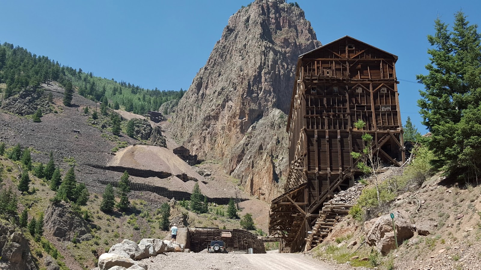
We had read about the Summitville Mine and Ghost town.  Curious, we took off, traveling down another dirt path for 18 miles.  We came finally found the ghost town of deteriorating wooden buildings.
We were surprised to see reddish-orange water in the stream not far from the road.  It was also an unpleasant feeling seeing the mountain cut away, knowing those toxic minerals in that stream were results of that mining process.

We also saw this newly built water treatment plant used to monitor and clean the toxic water run-off.  The Summitville Mine is a designated "Superfund Site". 
One can see how badly this mountain had been cut away for mining purposes.


 This yellow-bellied marmot sat very still for quiet a while, allowing me to get a good closeup picture. We spied it in the rocks along the side of the dirt road not far from the water treatment facility.

As we returned back on the same dirt path from the Summitville site, we came upon this fifth wheel in the "perfect" wilderness campsite.  What a view!


More later as we Eas-on Down the Road to Durango, Colorado.


Friday, August 21, 2015

The Bachelor Loop in Creede

At the last minute, we decided to take a drive to the town of Creede, about an hour drive northeast from Pagosa Springs.  I had read that the town was an interesting place and with a "rich" mining history too.  Of course, that means a trip over scenic Wolf Creek Pass.  Let's go!
Another view from Lobo Lookout, the summit of Wolf Creek Pass.
A view of the Wolf Creek Ski Area and Hwy 160 as it travels over Wolf Creek Pass.

The town of Creede has a colorful history of 1890's boom-town mining and gambling.  Highway 149, also known as The Silver Thread Scenic Byway, runs through Creede as well as other small historic mining towns.  We didn't make any special plans or research anything other than "let's get in the Jeep and go" so we didn't have but an afternoon to explore the town and the surrounding area.
Driving into town, we could see that it was a place we would love to explore.  Small shops with old store fronts, restaurants, art galleries, ice cream....
We continued to the end of town, where we could see that the road seemed to go up into a canyon.  Ronnie just kept driving to see where it would lead.
We were intrigued by the creek that was channeled into a man-made ditch. (Willow Creek)
As we rounded the curve, we traveled between the canyon walls to find an abandoned, yet very unique mining landscape.  We could see towering cliffs, interpretive signs and a gravel road seemingly, tempting us to go up further into the deep canyon. 
You can see the switchbacks from the old mining days here.  Horse drawn wagons were used to transport the silver and lead rock ore down that path.

The interpretive signs informed us that this was called the Bachelor Loop.  We were excited now..another scenic "Jeeping" road to explore with not just gorgeous scenery but some interesting history too!


Traveling up this gravel road, we suspect we are in for a real treat.
As we ride up the steep hill, we come upon an awesome sight of old, abandoned mines from the 1890's!  Wow, what history!
We learn that this is the Commodore Mine, last used in 1976. 
Zoomed in view of the mines further up on the cliff.
Across the creek, you see possibly an abandoned railroad trestle or a bridge for wagons barely clinging to the side of the mountain. (I later find out there is a pamphlet you can purchase in town with historical info about the mines and other landmarks.  I'm sure this info would have made our trip even better.)  It is fascinating to us to see this history..yet it is deteriorating right before our eyes.  We are glad we get to see it today, will it be here tomorrow for others to see?

Ronnie and I find it interesting to see old mining equipment just lying around.  The interpretive signs remind people to leave the historical evidence and abandoned mines alone as it is all on private property and many are unsafe.  Ron notes that this sheet metal is riveted together, not welded, possibly a clue to the age of all this mining equipment.

There is evidence of smaller mines along the roadsides and up on the cliffs.
We continue straight up this 17 mile gravel road..

 ...stopping to take photographs and marvel at the enormous cliffs surrounding us.

We turn around to see where we have come.  Again, another "Wow, look at that!" moment.

The next sites we arrive at are the Amethyst and Last Chance Mines.


Across the road we notice another possible mine entrance.  I'm not going in there.

The Bachelor Loop twists and turns upwards and gradually levels out at around 10,000 feet.  We pass by a few other abandoned mines and a couple of mines that have appear to have been sealed.


While we were traveling the loop, the discussion came up between us about the mining waste water spill on the Animas River.  We soon came upon the Park Regent Mine Site. It was sealed in 2003 using cement and kiln dust.
Nelson Mountain (12,099ft) is in the background.
Here is the interpretive sign describing the reclamation process used to seal this particular mine.  Note the "After" paragraph.  Various Mining Reclamation Committees were involved in this process.


We came to a fork in the road that lead to The Last Chance Mine.  We started down the path to visit the mine but gave up and turned around after we realized our afternoon time was running out.  We continued on the rest of the 17 mile loop where it soon passed an impressive lookout over the valley.  This area is where the old mining town of Bachelor City was once located.  Only sparse remnants of the once bustling town remain in the aspen groves.
Oh..but the view!

We found end of the Bachelor Loop as beautiful and stunning as the beginning.


We had just enough time left to stroll along Creede's main street and into a couple of shops. We did get a bite to eat at Kip's Grill and it was very tasty.  Unfortunately for us though, we missed visiting the Underground Mining Museum and the Historical Society's Museum, as they had closed for the day.  It would have been interesting to compare the western, historical mining artifacts/history to the modern ones we found in Lynch, Kentucky(from our blog post in September 2014).
I did catch a glimpse of this wonderful mural in Creede.

More later. 

Saturday, August 15, 2015

Scenic Drives and Scenic Soaks

This area of Colorado offers folks almost anything they could want in outdoor activities..whether it would be: action filled four-wheeling down thrilling mountain roads, quiet drives through pastoral meadows or hiking to waterfalls among tall aspen, spruce and Ponderosa Pines.  One can soak in calm, warm mineral waters or tube the chilly waters of the San Juan River.  You can mountain bike, fly fish or go horse-back riding. I'm sure there are activities I don't know about too!  Stopping at the Pagosa Springs Visitor Center was the best thing we did to try to decide what would interest us.  We chose the quieter, more calmer versions of exploring the Pagosa Springs area of Colorado.
We picked up the brochure "Hiking Trails and Scenic Drives".  We've found it to be a great guide for exploring this area.
 These photos are from our drive on the Blanco Basin Road. It was 42 miles, round trip, down a gravel dirt road.
Everywhere you looked, it appeared to almost be like a movie set or painting, it was so scenic.
 We saw some of the most beautiful mountain homes and cabins nestled in this valley.  Historic ranches with running rivers made us feel as if we had been dropped into a scene from a classic western film.
 Our drive up Castle Creek Road was even more spectacular.  The aspen forest was dense and filled with huge old growth.  We read that this is one of the best places in Colorado to view fall foliage.
We enjoyed a picnic at this lookout.  We had a clear view of the top of Nipple Mountain and the Rio Blanco Valley below.
 We continued to the end of Castle Creek Road where the Fish Creek Trail began.  You needed binoculars to see the homes in the valley.

The East Fork Road to Elwood Pass
was our next choice of scenic drives.  The road was rocky, full of pot holes yet filled with some unforgettable scenery.  Our Jeep Wrangler handled it without a care and we motored on to see some wonderful sights.
The road follows the San Juan River up through the Quartz Meadow.  There were no home sites on this road only some dispersed camping.

The San Juan river as it exits the Quartz Meadow.
Quartz Meadow..Elwood Pass is located up in those mountains.

We turned the Jeep around at the junction of the trail up to Elwood Pass and did not attempt the "strongly-recommended four-wheel drive trail" up Elwood Pass.  The first several hundred feet of this trail was nothing but deep, deep pot holes that only ATV 4-wheelers could traverse..not for us!  We did, however, enjoy several water crossings with our Jeep on the East Fork Road.

The history of Pagosa Hot Springs was among one of the interests
that drew Ron and I to explore this area of Colorado.  We tried to select a day less crowd to experience the calmness of the warm mineral waters..so did many other folks who were also hoping for a calm day of soaking. 
A view of The Springs Resort and the San Juan River from the scenic overlook in Pagosa Springs.  We saw adults and children tubing the river and also folks fly fishing.  River water temps are 58 degrees..don't know how they do it!
The newer Springs Hotel offers nice rooms with private outdoor soaking pools on terraces.  We could have soaked in those pools too for an extra cost.
Our view of the San Juan River from one of the soaking pools.
Looking up stream from a soaking pool.
I loved how the owners of The Springs Resort and Spa left the mineral terraces and what appeared to be an original soaking pond from long ago.
There were 18 pools with various temperatures.  This particular one was beautiful..but just too hot for us.
I also liked where you could see the hot mineral spring water being channeled throughout the premises. 
I thought the flowers and landscaping provided a nice touch between the many soaking pools.
Ahh..this pool was just right, about 93 degrees.


And we are still feeding hummingbirds..

More Later.