Tuesday, September 18, 2018

Views Of The Colorado River From Horseshoe Bend


Horseshoe Bend, located about 4 miles just south of Page on Hwy 89, is one of the most photographed places in this region.  Here, the Colorado River continues its meandering route from the Glen Canyon Dam, carving deep into the Navajo sandstone on its way through to the Grand Canyon.  On this day, we set out to early to walk the 3/4th mile one way trip, to avoid the 95 degree mid-day heat.  Our views are perfect and the crowds large.


A view from the right..

and a view from the left.

Whoa..now how did I get this river view?  Ronnie and I experienced a fantastic rafting trip with Wilderness River Adventures out of Page.  The company offers half day and whole day (what we took) river trips from Glen Canyon Dam and multi-day rafting trips on the Colorado River from Lees Ferry through the Grand Canyon. 


The small dot in the river is a fly fisherman.  This section of the Colorado River hosts rainbow trout where people pay river guide outfitters for access to those prime fishing spots.


Zoomed in and cropped, this is a photograph of the overlook platform where you view from the top of that famous horseshoe curve in the river.  Our River Guide tells us that the town of Page will be improving the overlook parking lot and trail next year.  Increased tourism there necessitates it.


A view of the center of the horseshoe..
and a closer view of the center of the horseshoe.

Here is a picture of the leftward curve in the Colorado River, our raft drifting on towards our "take-out" at Lees Ferry.  Most of the fly fishermen we see are fishing in the curve of the Horseshoe Bend.


Our raft trip begins with a security screening at the Wilderness River Center.  Since 9/11, security at all dams has highly increased.  Boarding their bus, we are transferred to the "put-in" located at the base of the Glen Canyon Dam. We travel a 2 mile tunnel, bored through the sandstone,  probably originally used for lower dam construction and maintenance.


These pictures were taken from the pedestrian walkway on the Hwy 89 Bridge, over the Glen Canyon Dam.  There was a specialized opening in 
 the fencing where I took this picture of the 
river rafts in the water.

 What a difference in size of these river rafts when seen in person!

 Looking up from the Colorado River at the Hwy 89 Bridge and the Glen Canyon Dam.  That's a house boat being transported on the bridge.


The Glen Canyon Visitor Center.

A view of the Dam's spill way.


We are underway.  Our River Guide was knowledgeable, the trip hot however enjoyable.  The company provided lunch, several bathroom stops and a relaxing time to soak in the incredible canyon views.


We see lots of greenery, birding wildlife and even some flowing springs on the canyon ledges and side cliffs.


Looking up at the steep canyon walls, you seem to get a dizzy feeling. Our Guide tells us that the canyon heights range from 700 feet (at the Dam) to 1000 feet at the Horseshoe Bend, to as much as 1400 feet at the highest point.


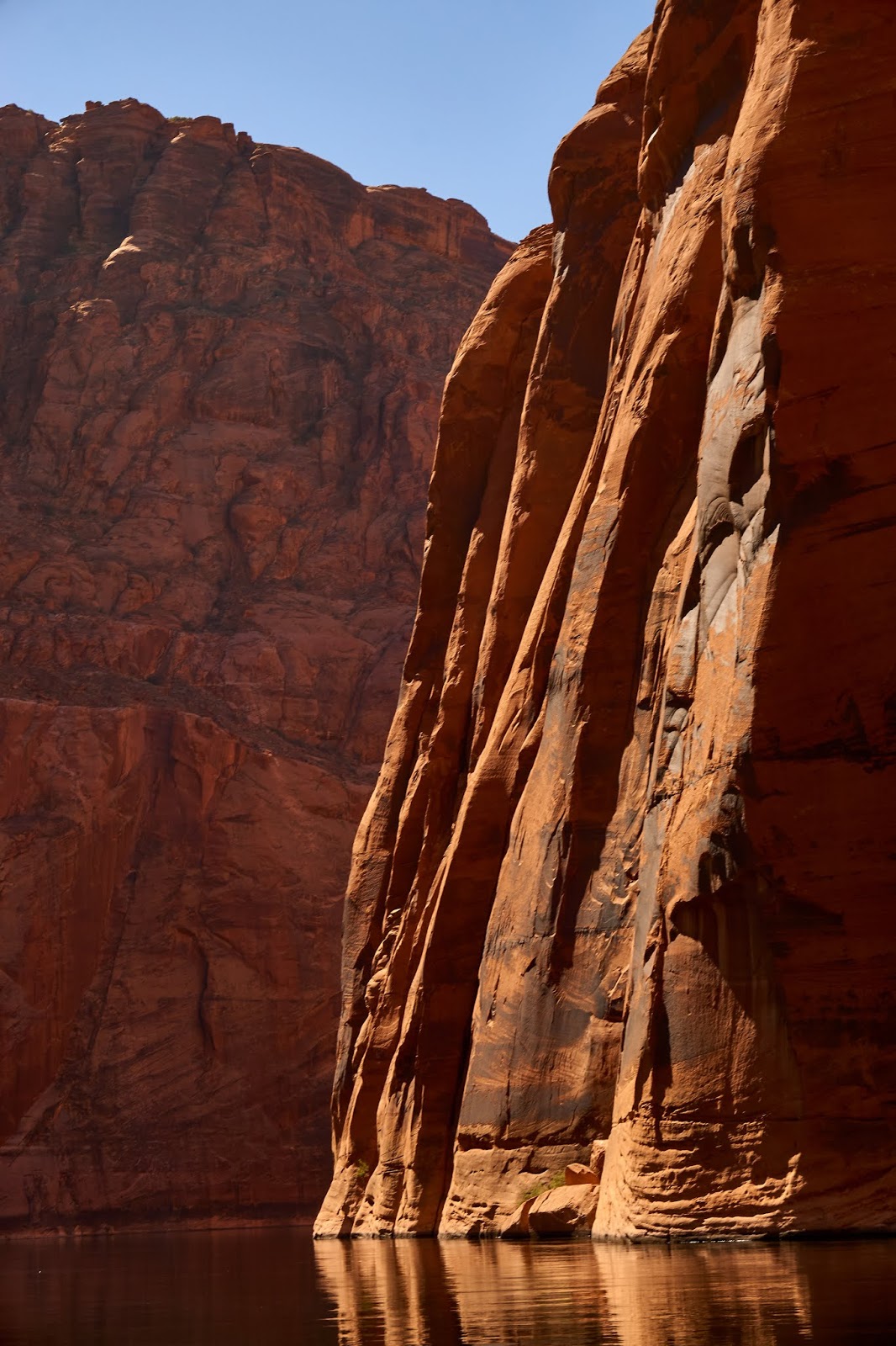
We see so many views of interesting carved canyon crevices, side canyons and over hangs.


   Our River Guide gives us lots of geology info on the sandstone and limestone layers, rock formations and how the dark splotches (canyon varnish) was all formed many, many hundreds of thousands of years ago.

The boats seen here are river transporters, they're taking folks with kayaks up to the primitive campground sites scattered along the river's edge.  They are coming from Lees Ferry.


Closer view of the canyon's intricate weathered patterns.


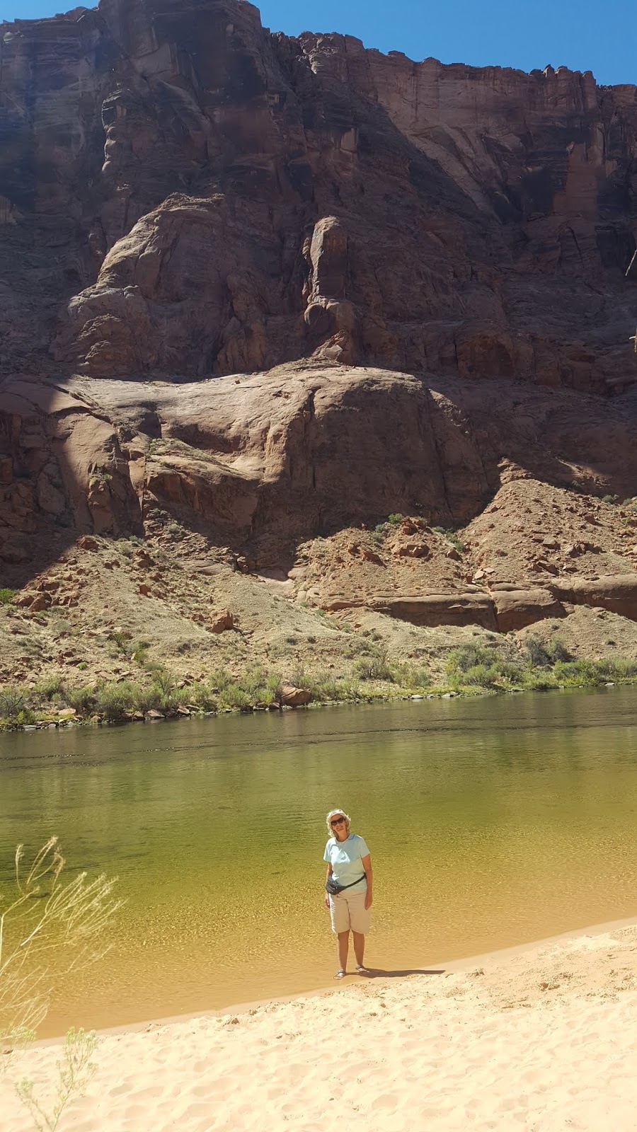
Our raft stopped just before the Horseshoe Bend for lunch.  We found a shady spot to rest and afterward I stepped into the cold Colorado River to prove I was there.


Continuing on the Colorado River, our Guide looks for shade as we gaze up the shear canyon walls.  We see herons, osprey, wild horses, several varieties of ducks..but no condors or bighorn sheep.


We hang our legs over the side of the big raft tubes for better down river views and a cooling water splash.


Our trip is approximately 15 miles from the Glen Canyon Dam to the take-out at Lees Ferry Landing.  We see height changes in the canyon walls, they get taller and taller, soaring to 1400 feet.


It becomes a challenge for me to fit the sky, canyon wall and river all in the camera's viewfinder.


Nearing the end of our trip, we enter the canyon section, 
Even though there is no marble, this historic explorer of the Colorado River named it "marble" because he thought the canyon walls appeared polished to him.


Too soon, our raft trip has concluded at Lees Ferry Landing.  We see excited rafters boarding the huge rafts for their multi-day 
/overnight journey into the Grand Canyon.  Can you imagine..?


More Later..from southwestern Colorado.


Thursday, September 13, 2018

Pictures from Page

So far, our 2 week visit to Page, Arizona has been relaxing and filled with some special experiences.  We could not get campground reservations at the preferred Wahweap Campground on Lake Powell but our stay at Page Lake Powell Campground in the town of Page has been fine.  We didn't have the Lake Powell water  views but Little Boy was happy with our desert view of the red Navajo sandstone hills.

Driving out on Highway 89 West, this bridge crosses over the Glen Canyon Dam 
with a view of Lake Powell and the Colorado River below.  We stopped to visit the Glen Canyon Dam Visitor Center, took a walk to the Scenic "White House" Overlook and drove out to Wahweap Point and Marina on Lake Powell.  


Views of Lake Powell from the Glen Canyon Dam Visitor Center

Glen Canyon Dam is 710 feet tall.  We opted out of the dam tour and the electricity generating plant this time because we did it in 2000.

Views of the Glen Canyon Dam from the Wahweap Hill Overlook .

This is Wahweap Marina on Lake Powell.  The boats in view are mostly large house boats that can be rented or owner-use for touring and vacations on Lake Powell.

We walked down to one of Lake Powell's public beaches to enjoy the cool water.

**********************

We made a day trip out to visit the Navajo Bridge and Lees Ferry Boat Landing, all part of the National Park, Glen Canyon National Recreation Area.

The original Navajo Bridge, built in 1929  is only used for foot traffic now, motorized traffic uses the newer bridge, built in 1995.  That's Hwy 89A (a shadow) to the left.


Photographs of the Colorado River from the Navajo Bridge.


Look carefully at the picture on the right.  The two white dots in the center of the river (upper portion) are the huge white water rafts filled with overnight rafters and their supplies.  The Lees Ferry Boat Landing is up river, here these folks are in for a lifetime experience- several nights of river camping and rafting on the Colorado River through the Grand Canyon.


Colorado River views at Lees Ferry. 

***********************

We were extremely lucky to find 2 open time slots to see the famous Upper Antelope Slot Canyon.  When we arrived to Page, I checked all five Navajo tour companies, all were booked out for the two weeks we had planned to be in the area.   I finally found 2 time slots available at the last company I checked (and unbelievably at the prime 10:00 am time) and booked them immediately.  Internet searches reveal that the Upper and Lower Antelope Slot Canyon sections see approximately 6000 visitors a day.  We saw several tour buses depositing lots of foreign tourists in the slot canyon parking lots, downtown Page tour company lots and even the grocery store! Yes, it was very crowded but these Navajo Guides are excellent in how they handle all of these people. I noticed they get the tourists to move along at a good pace, quickly give interesting descriptions of the history and canyon geology and still provide expert camera setting information.  Though we were a little bit rushed, judging by how crowded it was and how lucky we were to have even gotten a reservation, we were happy with our tour, Navajo Guide and photographs.


This is a view of the Upper Antelope Canyon as we exited it.  We turned around and our Navajo Guide walked us back through the slot canyon again to its entrance.  So, I guess you could say this is where the swift water enters Upper Antelope Slot Canyon to form the sculpted sandstone walls.

I really liked the semi-circle pattern here to the left.

I tried hard to only capture Ronnie's photo rather than herds of tourists.


Our Navajo Guide threw some sand on a ledge so photographers could capture the sand and hourglass effect. 


The noon hour is best for this slot canyon photography.  The light reaches down to the lower walls of the slot canyon.  It was fairly dark in the canyon but looking up, you could see strong sunlight illuminating the colorful sandstone.


Our Navajo Guide took these photographs of Ronnie and me with my cellphone's camera.  He posed us in the picture on the right, telling us to look up..cheesy I know but it displays the interesting curved linear lines of the sandstone layers with the sunlight beams.  Our tour lasted about 90 minutes which was enough for photographs but not enough for me to marvel at this unusual, natural  underground feature.  We were about 120 feet at the canyon's deepest point.

**************

Of course, we made a day trip to the North Rim of the Grand Canyon.  Driving to the northern rim on Hwy 89A, you pass by the beautiful Vermilion Cliffs National Monument.  
It is about 124 miles from Page, AZ to the North Rim Visitor Center.


Our day at the North Rim of the Grand Canyon was quiet, relaxing and memorable.  Our last visit here was the summer of 2000, Ronnie was barely able to get around with a walking cane, due to his broken leg.


On the Angel Landing Point Trail, we see up close, Beardlip wildflowers

and exposed twisty cedar branches and roots.
This visit, we get to walk out to Imperial Point and Angel Landing Point.


Off in the distance, near the horizon, you can see where the Colorado River has cut a deep ditch into the plateau.  I think the town of Page and Lake Powell is just below the horizon line.


Dusk's cooler temperatures bring out the lizards, looking for their evening meal.  I think this is a Plateau Fence Lizard.


More Later from Page, Arizona.